A few weeks ago (on January 10th, 2015), one day before flying back to Boston after a week in Montana, my partners and I decided to check out an intriguing route called California Ice. It was put up by some Yosemite climbers in a 2 year effort, after the first attempt end with a cart wheeling leader fall and a broken leg. There's not much information on the climb around the internet. It's definitely not on MountainProject. However, you if you dig around you'll find some beta. There's a trip report on Summitpost that sounds especially appealing:
If conditions are perfect, usually sometime in January, the entire drainage will be covered in good ice offering one of the longest continuous ice climbs in the country. If all the ice is in and you decide to top out on the plateau, this climb can exceed 3,000 feet of continuous ice climbing.
Combine that with the guidebook intro:
With an area so rich with incredible ice climbs and history, it is easy to use glowing superlatives when describing the routes in this book. That said, California Ice stands above the rest, and view as one of the most beautiful and classic ice climbs anywhere in North America.
Sign us up!
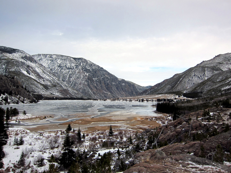
We hit the road around 5am, hoping the 3hr drive would put us at the parking area right around daybreak. The last 10 miles of the drive are down some really scenic state roads as you enter Custer National Forest. We didn't see a sign of anyone else in the area except some quite old tire tracks on the road as we drove into the canyon. We crossed a few rickety bridges and navigated some small snowdrifts, eventually turning the corner to see East Rosebud Lake (pictured below). Trying to save time and feeling confident in our 4×4 Yukon we plowed through some larger wind slab snow drifts until one finally swallowed us up. A few minutes of effort and we extricated ourselves and retreated to a pull-off about 0.4 miles from the trailhead we were hoping to reach. Not too bad.
Approaching the Beartooths in the morning:
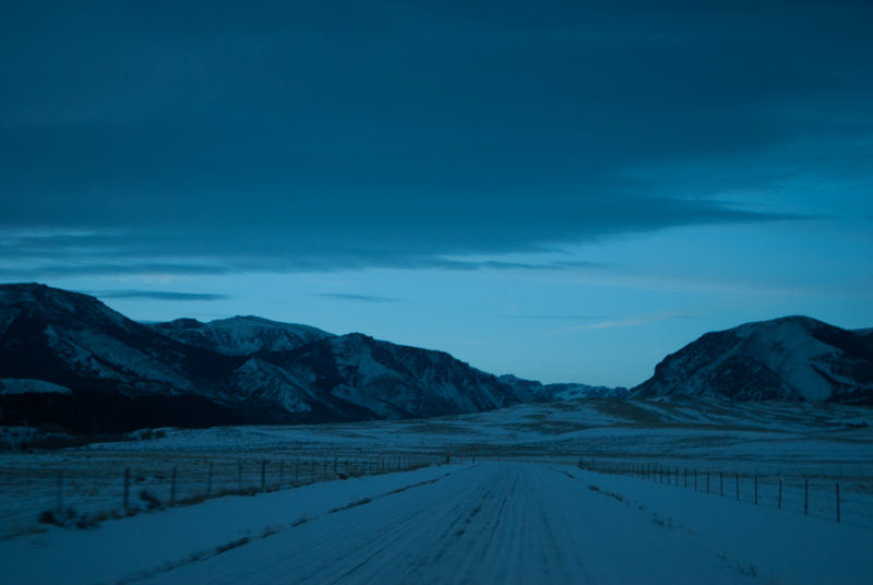
Start of the approach, East Rosebud Lake and summer homes in view:
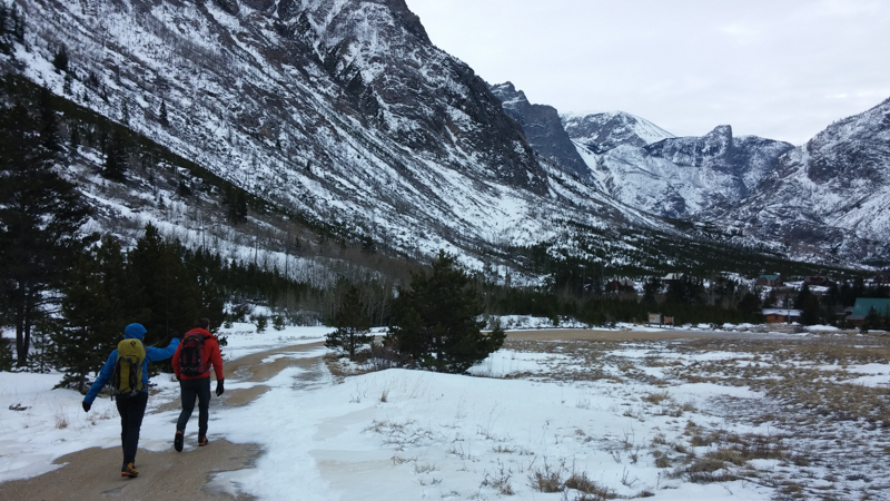
Stoke was quite high as we hiked into the canyon. A clear day. No one around for miles. The views of East Rosebud Lake just get better the further we go. We start to see glimpses of other ice climbs and huge rock walls, one even rivaling half dome in shape and size.
East Rosebud Lake:
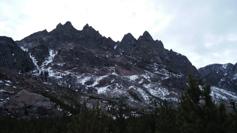
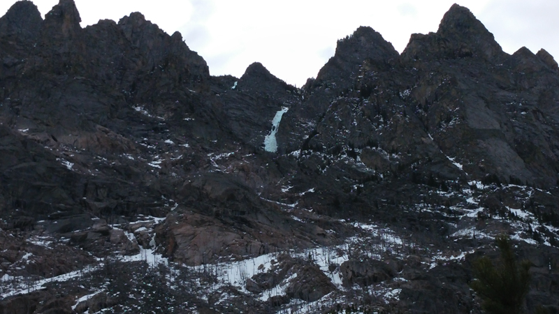
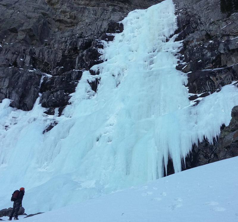
Then, finally, we see it! Big ice, high up on the wall. The main incentive for us to do this route was the crux section of ice. It's a really impressive flow, 80 meters of continuous WI4. Just a massive wall of ice way above the canyon floor. And now, even from ~2,000ft below at the base of it's easily noticeable.
The climb is visible in the upper middle of this picture
Zoomed in view of the headwall:
We continue to hike down the trail, eventually passing over "The Hump", a huge section of rock cliff that had been blasted away for the hiking trail. This marked the spot for us to start upward. We had our choice of two gullies and opted for the left side. It looked leaner in snow so we thought the going would be quicker. The first few hundred feet were pretty annoying, hiking through an old burn area from the 90's with lots of down trees. After this section we were immediately forced to stop and put on our crampons for a section of consolidated snow and ice. A rightward rock traverse for a few hundred feet a little later dropped us into the proper gully.
From here we started the slog upward, now officially on route we thought. At this point it was a moderate snow climb, however, we could see some ice bulges ahead. I was (or at least my calves were) a little bit relieved by the snow and the lack of an epically long ice climb.
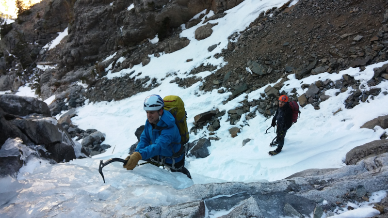
Dan climbs one of the early ice sections as Tom looks on from below, waiting his turn to swing the tools
We continue onward. The fatigue of the last week starts to become apparent. Maybe no rest day all week was a bad idea? Tom sets the pace and I struggle to keep up with him, although this is usually the case on any day out with him.
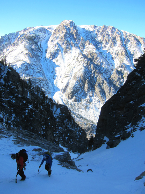
Dan and I slog up, the impressive Beartooths in the background
As time goes by, a growing doubt develops in my head. Are we in the right gully? Man, that would suck if we weren't. We pull out our maps and phones, hoping for some GPS service. No luck on cell service, but based on the topography on the map we think we're still on track. A little further along we see a WI3 section ahead that looks familiar from one of the trip reports. Tom goes around it to see if there is an easier/quicker way. Dan decides to just solo up it. Once Dan has enough distance between us I start to follow him. Right as I do, Tom pops around the corner, down from the snowy left side. He found an easier way, although we all opted for the ice section in the end.
It was not long after that where we finally got our first view of the main ice flow. It looked awesome.
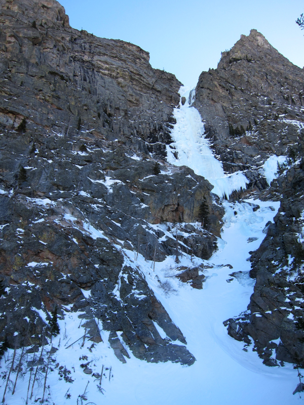
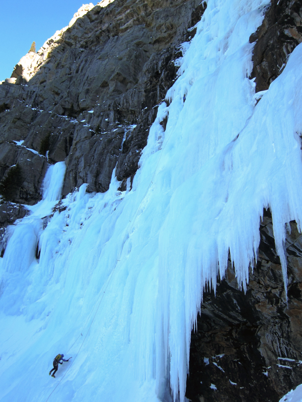
Tom eyes up the main flow of ice, trying to pick the best line
We got to the base and checked the time. 1pm. We had to get moving. Our goal was to get to the top of plateau before sunset so that we could hopefully identify the decent trail in the daylight. I offer to lead the first pitch and they agree. I quickly rack up, eat a snack, drink some water, and start off. I was aiming for a sort-of ledge halfway up on the right. However, not long after setting off I got lost in the sea of ice around me and pushed a little to the left of my intended route due to the poor ice conditions on the right side. At around 55m I stop at a section that seemed like it would offer some protection from falling ice on the nice pitch.
Dan starts off on the first pitch, I'm at the belay half way up the flow.
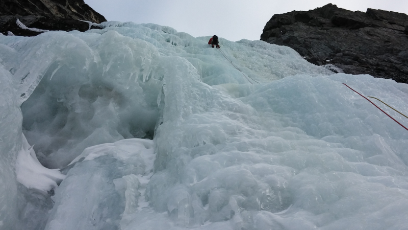
Both Dan and Tom climb quickly up to me but the hanging belay make it feel much longer than it was. Hanging belays suck. They especially suck on ice. We hastily trade gear with Tom and don our large belay jackets to stay warm. Dan rigs a rest for our knees with his backpack so we don't have to press them on the cold ice while hanging in our harnesses. Tom takes off on the next pitch. He moves steadily upward through what looked like pretty challenging ice conditions. He clears over the lip of the steep section - nice! However, we realize that once he did, the relative safety of our position is gone. Chunks of rotten ice from above start to whiz past us. I take a piece off the leg. Shit! After a few minutes of this, we finally get the call, "Off Belay!" Thank god. Luckily my leg wasn't too bad after the initial shock went away. Now we can move and try to get warm again. My micro puffy stays on.
Tom leads up the second section of the WI4 main flow
Thankfully Tom had found a nicer ledge to belay from this time around. We didn't hang out there for too long though; the daylight was starting to wane. We could do a v-thread, make 2 rappels down this flow, and then down-climb the gully back to our car. However, after the long day we've had getting to this point, we were all in agreement that the plateau and hike off sounded more appealing. How much more ice could be left anyways, right?
Me seconding one of the upper ice pitches
Trying to get as far as we could given the easier terrain of course meant that our next 70m pitch would end at another hanging belay. Sigh. How much ice still lay ahead over this next bulge now? Headlamps came out before starting the next pitch, but they didn't have to be turned on quite yet. As Tom was cruising up the the next pitch of moderate ice on lead I was confused to hear cursing at the halfway point. A few minutes later, as soon as I started to follow the pitch I was clued in to his frustration as the rope was literally running with water! One of his swings caused a big fracture in the ice, opening up a massive ice damn. Water was flowing like crazy over our ropes. I got soaked.
Thankfully the top of this pitch opened up to some easy ice and eventually to snow climbing again. We could see more ice up and right. We could see trees up and left. Dan and I headed up for the trees, soaking wet and under the glow of our headlamps at this point. We just finished 4 long pitches, totaling about 220m of climbing before this scramble. We knew the plateau was a few hundred feet ahead of us. We also knew that we had to eventually head left on the descent so we figured that un-roping and moving up the left side made the most sense. Given more time, the ice on the right would probably be the better way.
This upper section consisted of some stout upward tree climbing, some wallowing in snow, some interesting rock and mixed moves, and it was generally longer than any of us were hoping for. I would say it took another hour of climbing to get to terrain that we felt comfortable with and could breathe easier...a little bit anyways. There was some cloud cover that night so visibility was low and there was a steady wind once we got to the plateau so we weren't necessarily in a good place yet.
The plan was to say near the cliff band and hike up to the high point and 10,400 ft. I was moving really slow at this point due to slight dehydration and being low on fuel. The other guys were constantly pulling ahead on the hike upward. Just had to make it to the high point and I'd be okay. It's times like this where having good partners is crucial. Since they were moving faster, they helped coordinate navigation. The hopes of finding the hiking trail down were slim to none since there are no cairns on the plateau. It's such a wide, flat land that there are no established trail markers once you get to that point. So we aimed for what looked like a long drainage system on the map that we hoped would be a snow gully.
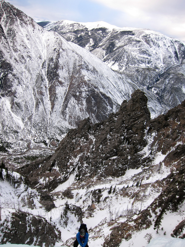
What we started descending was a rock ridge. It was loose and slow going, but at least the wind was calmer than it had been on the exposed plateau. We were pretty happy to find snow a half hour after we started this descent. It was good snow, but pretty steep. The kind of movement where you face in, both tools punched straight into the snow and kick steps, essentially climbing a ladder down the slope. Luckily the darkness helped hide the exposure. It was secure feeling, being faced in and all, but you didn't want to fall. We were all aware of that. But we kept moving. Tom was in the lead, kicking steps for an hour. We covered a lot of ground. I couldn't believe how long this gully was. It was the same repetitive movement, but we were glad to be moving down. When I took over the lead down I figured there couldn't be much more of this, but it just kept going! I'd say it was 2,000+ ft of down-climbing in this same manner. Really cool and really memorable.
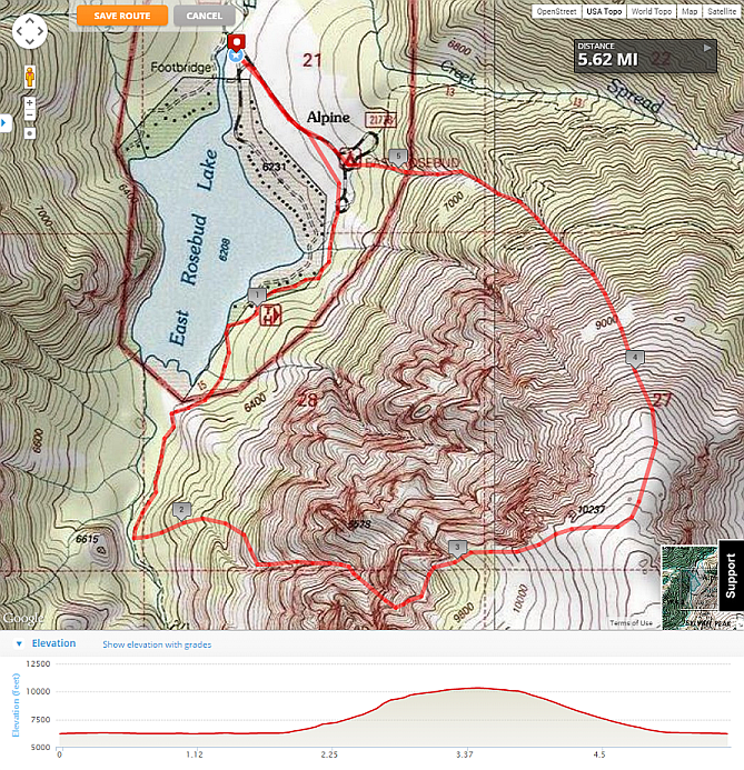
Red line was our route for the day
Finally, the slope became less steep. Our kicks started to sink in to the warmer, deeper snow at the lower and flatter elevation. Facing in changed to walking down in big steps. It was awesome! We covered a ton of ground in 15 minutes. We could make out where the lake was. The last hour turned into pure hell though. Waist deep soft snow and downed trees all over. Ever step you'd sink in and possibly wrench your foot on a long, even if you weren't the one breaking trail.
In the end we made it out and back to the car by 12:45am - a 16 hour day. A great way to finish a weeklong trip. It took me a week to recover I'd say, but it was totally worth it. We got back to our house in Bozeman around 4:30am, enough time to get about 2 hours of sleep before we had to wake up and pack for our flight.
Post-climb:
So after searching around the internet a little bit before writing this trip report, I came to the realization that the one trip report we did find that showed the descent trail (following the summer hiking trail) was not the actual path of those that wrote the report. They rapped the route! To those reading this for beta, I would definitely recommend the walk-off. But start early, real early. And if you find good snow conditions like we did, go down that gully - it's impressive (and safe).
Gear:
2x 70m ropes
13 ice screws
no rock gear